
Introduction: Why Traffic Safety Matters
Traffic safety is a top priority for municipalities, state agencies, and federal organizations. With the rise in road accidents and fatalities, it’s more important than ever to employ advanced solutions to make roads safer. Traditional methods of traffic monitoring are often slow, costly, and limited in scope. However, emerging technologies such as data analytics and drones are changing the game. These tools allow authorities to make data-driven decisions, pinpoint problem areas, and implement corrective measures more efficiently. By integrating these technologies, cities can reduce accidents, lower traffic-related fatalities, and improve public safety. A data-driven approach also helps build more resilient infrastructure that can adapt to changing traffic patterns over time. With drones providing aerial insight and data analytics driving informed decisions, the future of road safety looks brighter than ever.
The Role of Data Analytics in Traffic Safety
Data analytics has become a vital tool in traffic safety management. By analyzing data collected from various sources—such as traffic cameras, sensors, and GPS devices—cities can uncover patterns that indicate safety risks. For example, speed data can highlight areas where speeding is a consistent problem, while crash data shows where accidents tend to cluster. Advanced algorithms can also predict potential traffic bottlenecks and identify critical areas for infrastructure improvements. These insights allow city planners and engineers to make informed decisions on road designs, signal placements, and safety measures. Data analytics helps reduce the guesswork, ensuring that every decision is backed by empirical evidence. When used effectively, data analytics can save lives and reduce accidents, leading to smarter, safer roadways.
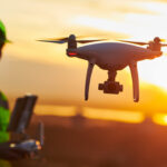
How Drone Services Enhance Traffic Inspections
Drones are revolutionizing the way traffic infrastructure is inspected. Unlike traditional methods, which can be time-consuming and require manual labor, drones provide a fast and cost-effective alternative. Aerial drone inspections allow for a comprehensive overview of traffic signs, signals, and road conditions. With high-definition cameras and sensors, drones capture real-time footage of traffic infrastructure, identifying damage or wear before it becomes a safety concern. Drones also improve accessibility, allowing inspectors to reach hard-to-access areas like overpasses or tall signal poles without the need for scaffolding or cranes. This leads to safer, quicker inspections with minimal disruption to traffic flow. Furthermore, drones can gather data from multiple angles, giving inspectors a more complete understanding of the infrastructure’s condition.
High Crash Location (HCL) Analysis and Its Benefits
High Crash Location (HCL) analysis is essential for identifying the most dangerous areas on the road. By studying accident data, engineers can pinpoint locations where crashes occur more frequently and with greater severity. This allows for targeted interventions, such as adding traffic signals, improving signage, or implementing pedestrian safety measures. HCL analysis can also help prioritize infrastructure upgrades, ensuring resources are allocated efficiently. For example, if a certain intersection consistently reports high crash rates, engineers can focus on redesigning the layout, adding turn lanes, or improving visibility. With the right interventions, HCL analysis can significantly reduce accidents and fatalities. This proactive approach helps prevent accidents before they happen, rather than reacting after the fact.